
28 September 2018 - Air Niugini 73
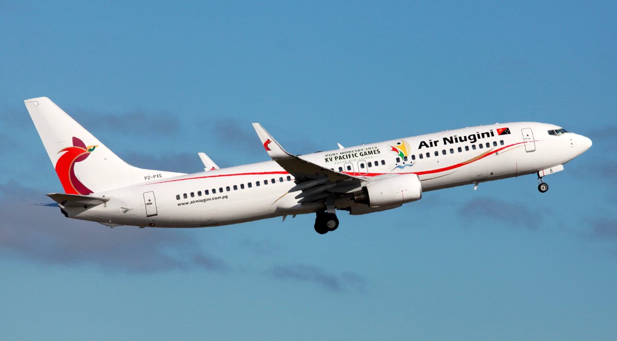
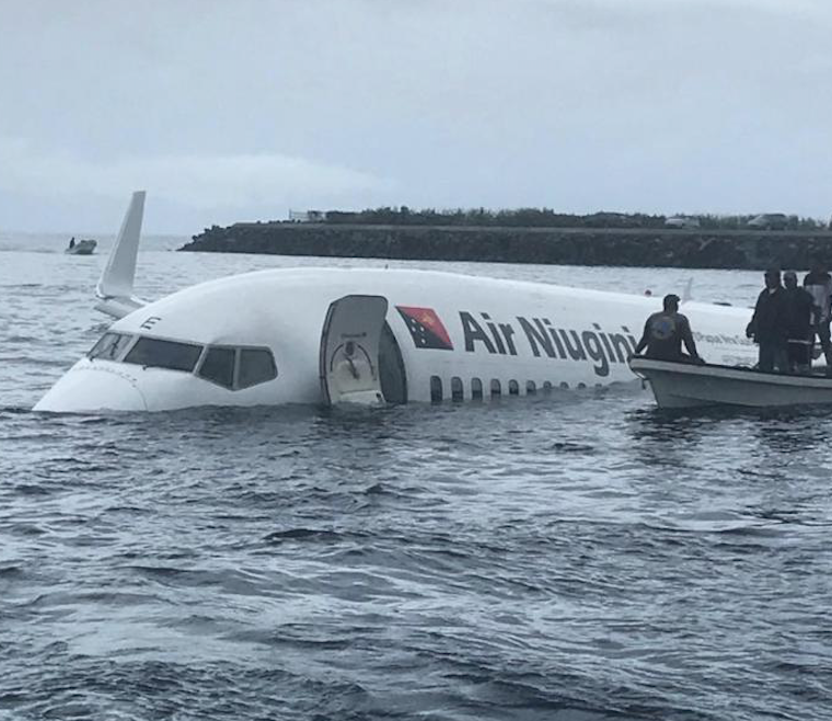
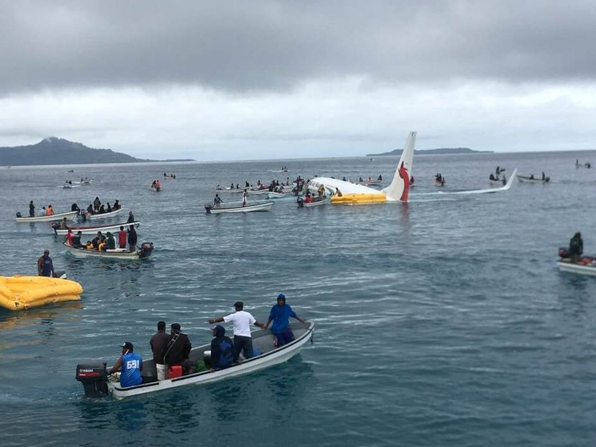
On 28 September 2018, at 23:24:19 UTC2 (09:24 local time), a Boeing 737-8BK aircraft, registered P2-PXE (PXE), operated by Air Niugini Limited, was on a scheduled passenger flight number PX073, from Pohnpei to Chuuk, in the Federated States of Micronesia (FSM) when, during its final approach, the aircraft impacted the water of the Chuuk Lagoon, about 1,500 ft (460 m) short of the runway 04 threshold.
The aircraft deflected across the water several times before it settled in the water and turned clockwise through 210 deg and drifted 460 ft (140 m) south east of the runway 04 extended centreline, with the nose of the aircraft pointing about 265 deg.
The pilot in command (PIC) was the pilot flying, and the copilot was the support/monitoring pilot. An Aircraft Maintenance Engineer occupied the cockpit jump seat. The engineer videoed the final approach on his iPhone, which predominantly showed the cockpit instruments.
Local boaters rescued 28 passengers and two cabin crew from the left over-wing exits. Two cabin crew, the two pilots and the engineer were rescued by local boaters from the forward door 1L. One life raft was launched from the left aft over-wing exit by cabin crew CC5 with the assistance of a passenger. The US Navy divers rescued six passengers and four cabin crew and the Load Master from the right aft over-wing exit. All injured passengers were evacuated from the left over-wing exits. One passenger was fatally injured, and local divers located his body in the aircraft three days after the accident.
>>> Download HERE the full Final Accident Investigation Report
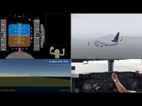
The PIC intended to conduct an RNAV GPS approach to runway 04 at Chuuk International Airport and briefed the copilot accordingly. The descent and approach were initially conducted in Visual Meteorological Conditions (VMC), but from 546 ft (600 ft)4 the aircraft was flown in Instrument Meteorological Conditions (IMC).
The flight crew did not adhere to Air Niugini SOPM and the approach and pre-landing checklists. The RNAV (GPS) Rwy 04 Approach chart procedure was not adequately briefed.
The RNAV approach specified a flight path descent angle guide of 3º. The aircraft was flown at a high rate of descent and a steep variable flight path angle averaging 4.5º during the approach, with lateral over-controlling; the approach was unstabilised. The Flight Data Recorder (FDR) recorded a total of 17 Enhanced Ground Proximity Warning System (EGPWS) alerts, specifically eight “Sink Rate” and nine “Glideslope”. The recorded information from the Cockpit Voice Recorder (CVR) showed that a total of 14 EGPWS aural alerts sounded after passing the Minimum Descent Altitude (MDA), between 307 ft (364 ft) and the impact point. A “100 ft” advisory was annunciated, in accordance with design standards, overriding one of the “Glideslope” aural alert. The other aural alerts were seven “Glideslope” and six “Sink Rate”.
The investigation observed that the flight crew disregarded the alerts, and did not acknowledge the “minimums” and 100 ft alerts; a symptom of fixation and channelised attention. The crew were fixated on cues associated with the landing and control inputs due to the extension of 40° flap.
Both pilots were not situationally aware and did not recognise the developing significant unsafe condition during the approach after passing the Missed Approach Point (MAP) when the aircraft entered a storm cell and heavy rain. The weather radar on the PIC’s Navigation Display showed a large red area indicating a storm cell immediately after the MAP, between the MAP and the runway.
The copilot as the support/monitoring pilot was ineffective and was oblivious to the rapidly unfolding unsafe situation. He did not recognise the significant unsafe condition and therefore did not realise the need to challenge the PIC and take control of the aircraft, as required by the Air Niugini SOPM.
Prior to top of descent (TOD) the crew briefly discussed brake setting for the landing.
The pilots then commenced a discussion about the approach and landing flap setting. The copilot asked the PIC if they should use Flap 30 and the PIC replying “Yeah, Flaps 30 would do. 141 plus 5 ah”. The discussion continued around whether to use Flap 30 or 40. The copilot entered the relevant conditional data into the electronic flight bag (EFB) Boeing OPT and determined that the use of Flap 40 would reduce the landing distance required by about 150 meters. He informed the PIC and the PIC agreed to select Flap 40.
They then discussed the approach and missed approach procedure they would conduct at HAMAX if they found themselves not visual by that point. However, the approach and landing checklist and the briefing on the RNAV approach chart briefings were not conducted in accordance with the SOPs and not using standard phraseology. The missed approach was just a cursory mention of DAMAY and did not cover the procedure, nor the flight path to be followed.
At 22:54:36, San Francisco radio contacted the crew with the following decent clearance: ATC clearance. Niugini 73, descend to reach FL340 by time 23:05Z13, requirement to reach FL340 by time 23:05Z, and report level, FL340. Cruise, FL340, to Chuuk airport, report arrival. Report leaving FL280, flight level 180 and flight level 080, time, time check, 254 and a quarter. At top of descent, the PIC stated to the copilot that they were already high and needed to immediately initiate their descent. The crew commenced their descent leaving FL40014 at 22:56:18, at a descent rate of 944 ft/pm. At FL340, the copilot contacted San Francisco radio and reported that they were maintaining FL340. Both pilots discussed the descent clearance for about two minutes, trying to recall and clarify the instructions that they were given.
At 23:05:14, while maintaining FL340, the PIC stated to the copilot that they were high on profile and needed to descend to get back on the required descent profile.
At 23:08:16, the PIC said “alright, we catching back on profile, so just keep the speed up”.
The copilot contacted Chuuk radio at 23:08:54 and requested a weather update. Chuuk radio acknowledged and asked the crew to standby for the weather update. The PIC, realising that they were still high on profile, instructed the copilot to go on VNAV.
At 23:11:00, Chuuk radio contacted the crew with the weather update for Chuuk stating: “wind variable at 5, visibility 14 scattered 012 charlie bravo, broken 120 overcast 280, temperature 26 dep point 25, altimeter 2973”.
At 23:11:25, the copilot reported passing FL180 to San Francisco radio.
At 23:15:59, at about 15 nm from Chuuk while passing 8,600 ft, the copilot made an inbound broadcast call stating their intention to track for the RNAV (GPS) runway 04, from the east south-east. Shortly after the broadcast the copilot contacted San Francisco Radio, and reported passing 8,000 ft on descent.
Prior to commencing the approach, while on descent through 4,000 ft, the PIC stated “Alright, the missed approach is” but he did not continue and the copilot did not respond. The PIC did not continue his statement/question with respect to the missed approach briefing.
23:20:53 The PIC stated to the copilot: “okay, we on RNAV at 041 and I’ll go 1,000.” Shortly afterwards at 23:21:07, the copilot made a general broadcast, stating that they were established on 041 inbound via the RNAV (GPS) runway 04.
23:21:27 The PIC called for gear down and flaps 15 and stated: “we just configure as we can ah.” The PIC did not complete his instructions to the copilot.
23:22:33 The copilot mentioned to the PIC that there were some showers in the area and the PIC acknowledged by stating: “That must be some storm, but it’ll be out soon.” The PIC called for the landing checklist, but the only readout made by the copilot was landing gear, flaps and lights and runway in sight.
23:22:42 The PIC said to the copilot: “ah we’ll probably just go down on the PAPI’s.” Seven seconds later the PIC said: “alright flaps 30, flaps 40”.
23:22:54 The PIC said: “landing checks.” At the EGPWS 1,000 ft altitude call-out, the copilot told the PIC: “OK, stable.” Four seconds later the PIC said “continue.” The copilot then said: “and visual, 900 cloud base.”
23:23:41 The copilot set the missed approach altitude on the Mode Control and shortly afterwards, when passing 625 ft (677 ft)17, with the aircraft above the 3º glideslope, the PIC disconnected the auto-pilot and stated: “I’m going back on profile.”
23:23:43 When passing 548 ft (602 ft) on descent, the aircraft entered the storm cell and heavy rain and the PIC called for the wipers to be switched on. The PIC stated during the investigation interview that he had already made the decision that it was visual up ahead with the runway edge lighting to continue for landing at that stage.
23:23:49 The PIC said: “okay, landing.” 23:23:52 The copilot said “visual, one red,” [pause] “three whites.”
23:23:53 EGPWS MINIMUMS call-out.
23:24:00 As the EGPWS call-out was repeating “Sink Rate, Sink Rate,” the PIC said: “I just wanna get on profile” (over the top of the last “Sink Rate.”)
23:24:03 EGPWS call-out repeated “Glideslope, Glideslope, Glideslope.”
23:24:06 EGPWS call-out repeated “Sink Rate, Sink Rate.” and the PIC said to the copilot: “that’s fine, I’ll just go a little bit more.”
23:24:09 EGPWS call-out repeated “Glideslope, Glideslope.”
23:24:11 The copilot rapidly asked, “See the runway?”
23:24:12 EGPWS call-out “100, Glideslope” and the PIC said “Monitor airspeed. Okay, got it.” (The FDR recorded a Glideslope alert but it was over-ridden by the EGPWS “100 ft” call and was not recorded on the CVR.)
23:24:13 EGPWS call-out repeated “Glideslope.”
23:24:17 (EGPWS call-out “SINK RATE, SINK RATE”). Copilot called rapidly with high intonation: “Too low! We’re too low! We’re too low! We’re too low!”
End of recording.........
Actual flight profile
The aircraft was being flown on a RNAV (GPS) approach to runway 04. While the auto-pilot system was engaged, the approach was stabilised, tracking 041º from FIGBI 2,500 ft, passing FASPO at 1,700 ft. The PIC disconnected the auto-pilot at 625 ft (677 ft) and flew the aircraft manually.
The missed approach required a left turn to track 306º with a minimum rate of climb of 375 ft / NM tracking to 960 ft to the Missed Approach Fix DAMAY.
From 548 ft (602 ft) the approach became unstabilised with an excessively high rate of descent and lateral over controlling. During the investigation interviews the PIC explained that from experience, he found the Boeing 737-800 aircraft laterally less stable with Flap 40 compared with the Flap 30 setting.
During the approach at 23:23:53, when the EGPWS Advisory alert (altitude callout) “Minimums” sounded, the aircraft was passing through the published MDA at 420 ft (477 ft) with a rate of descent of 1,490 ft per min. The descent was not arrested by either pilot.
After passing the MAP, the aircraft was progressively flown below the glideslope on an approach path from 411 ft (466 ft) ft to the point of impact that averaged 4.5º. Between the MDA and the impact point, the aircraft flew for another 22 seconds; the EGPWS issued seven Glideslope and six Sink Rate aural alerts.
The first Sink Rate Alert was annunciated at 23:24:00 when the aircraft was at 307 ft (364 ft) with a descent rate of 1,530 ft per min. The last Sink Rate Alert annunciated 2 seconds before impact at -13 ft (30 ft) and a rate of descent of 1,200 ft per min. The crew disregarded all these EGPWS alerts and continued the unstable approach at an excessive rate of descent in IMC from 23:24:00 to the time of impact at 23:24:19.
A storm cell situated immediately after HAMAX, the MAP, was painted on the weather radar on the PIC’s EFIS Navigation Display. The crew continued past the MAP and flew into IMC, through light and subsequently heavy rain. The copilot activated the windscreen wipers.
About 3 seconds prior to impact the aircraft was descending through -13 ft (30 ft) at a rate of 1,200 ft/min. Two seconds before impact the copilot rapidly stated with high intonation: “Too low! We’re too low! We’re too low! We’re too low” and the EGPWS sounded: “Sink Rate, Sink Rate” as the aircraft impacted the water.
Search the database
