
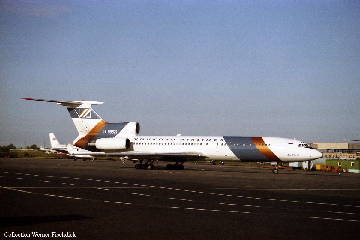
29 August 1996 - Vnukovo Airlines 2801
Vnukovo Airlines Flight 2801, a Tupolev Tu-154M built in 1986, with registration RA-85621, was a chartered flight from the Russian company Vnukovo Airlines which on August 29, 1996 crashed into a mountain on Spitsbergen in the Svalbard archipelago, killing all 141 people on board.
Vnukovo Airlines flight VKO 2801 departed Vnukovo Airport at 04:44 hrs GMT bound for Svalbard Airport Longyear. It was a chartered flight with workers and their families to coal mining towns at Svalbard.
The flight was normal until the start of the descent. Before radio contact with Longyear Information, the crew went through the detailed landing procedure for runway 10. At 09:56 hrs, the crew were cleared to start the descent. A little later, the crew received additional information consisting of runway in use 28, wind 230deg at 16 knots, visibility more than 10 km, rain showers, clouds: few at 1500 ft, scattered at 2000 ft and broken at 4000 ft, temp. 5degC, dewpoint -0deg C and QNH 1005 hPa. (Later changed to 1006 hPa). The crew tried to request runway 10 for landing twice, but the request was not understood as such by Longyear Information due to language difficulties.
When the flight was overhead the ADV beacon, at 10:15 hrs, the crew reported the position to Longyear Information and entered the base turn with a bank angle of 22deg. At 10:16 hrs, the aircraft came out of this turn on magnetic heading 160deg. During the right turn to the base turn, a malfunction occurred in the electric trimming mechanism, which was corrected by the crew. At 10:17 hrs, the crew started the turn to bring the aircraft out on the magnetic inbound course 300deg, as prescribed by the approach chart. The distance from the airport at this moment was 14 NM (25.9 km), as prescribed by the approach chart, but the lateral deviation from the outbound magnetic course 155deg from ADV was 2 NM (3.7 km) to the left.
At 10:18 hrs, after the radio altimeter aural warning had been activated twice, the co-pilot took the controls and, after 6 seconds, turned the autopilot pitch channel off by 'overriding' it. From then on until the impact, the flight continued in autopilot mode in the roll channel, and in manual mode in the pitch channel. The aircraft passed through the localizer centerline and when the turn had been completed, the aircraft rolled out on a magnetic heading of 290deg. At this time, there was a discussion within the crew as to whether or not the final turn had been made at the correct time. The discussion led to the roll out of the turn to final approach and a corrective turn to the right to magnetic heading 306deg. At this point, the aircraft was 14.7 NM (27.4 km) from the airport, 2.8 km to the right of the approach centerline, maintaining an altitude of 5000 ft (1520 m ) and the crew increased the flap setting to 28deg. The airspeed was reduced to approx. 330 km/hr (180 kts).
Instead of intercepting the centerline, the crew continued the flight on the right side, more or less paralleling the localizer course with minor heading changes. At 10:20 hrs the flight made a corrective turn, resulting in a track close to 300deg. At this point, the lateral deviation from the approach centerline was 3.7 km to the right. During this corrective turn, the aircraft started descending. At 10:21hrs, the crew made yet another corrective turn to the right. At 10:22:05 hrs, the aircraft started turning towards the left. The distance to the airport was 8 NM (14.8 km). On this part of the final approach, the aircraft apparently entered an area of strong turbulence created by the proximity to the mountains.
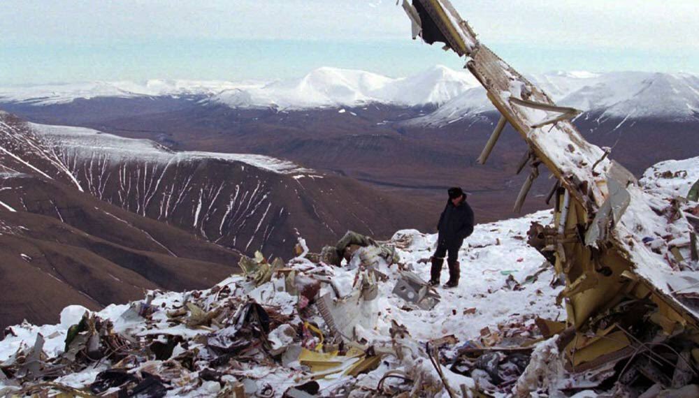
The GPWS then activated 9 seconds before impact. The crew reacted to this by applying power and initiating a pitch-up. At 10:22:23 hrs, 7.7 NM (14.2 km) from the airport at an altitude of 2975 ft (907m), the aircraft collided with the top of the mountain Operafjellet 3.7 km to the right of the approach centerline.
Eighteen significant factors have been identified as leading the flight to the disaster. For example, inadequate planning, unsatisfactory crew resource management and monitoring, a lack of a suitable procedure for offset localizer approaches in connection with an inappropriate rule requiring the landing course to be set instead of the localizer course, not solving navigational problems at safe altitude, not discontinuing the approach when procedural uncertainties exist, limited knowledge of the operating language and the actual airspace with respect to service given.
Transcript of the Cockpit Voice Recorder (CVR)
| Legenda PiC = Voice identified as Pilot-in-Command (PIC) Cop = Voice identified as Co-Pilot (SIC) F/e = Voice identified as Flight engineer Nav = Voice identified as Navigator U = Voice unidentified AFIS = Longyearbyen AFIS Traff. = Radio transmission from Longyearbyen |
| 8:16:55 | Nav | No, seven miles here. |
| 8:16:56 | Nav | I'll adjust it. |
| 8:17:05 | Cop | Where are we --- ? --- (ind.). |
| 8:17:06 | Nav | Meanwhile, keep it like that! |
| 8:17:08 | Pic | Did you notice the place? |
| 8:17:09 | Nav | Abeam the turning point. |
| 8:17:14 | Pic | A corrective turn will be (?necessary). |
| 8:17:16 | U | We're approaching. |
| 8:17:21 | Pic | Now we will be (?the flaps) (ind.) |
| 8:17:40 | AFIS | VKO 2801 give me a call eight miles inbound. |
| 8:17:43 | Radio altimeter warning, duration 6 seconds. | |
| 8:17:44 | Nav | Call you back ten miles inbound, 2801. |
| 8:17:55 | AFIS | VKO 2801, give me a call eight miles inbound. |
| 8:17:57 | F/e | Eight miles (In the English language). |
| 8:17:57 | Nav | Ah - abeam eight miles 2801 inbound - - |
| 8:17:59 | AFIS | Correct. |
| 8:18:05 | U | Four marks (ind.). |
| 8:18:08 | Pic | But here it's already three. |
| 8:18:14 | U | There's no need to --- here! |
| 8:18:16 | Radio altimeter warning, duration 2 seconds. | |
| 8:18:17 | U | --- to descend. |
| 8:18:19 | Cop | The flag disappeared on my instrument! |
| 8:18:21 | Radio altimeter warning, duration 6 seconds. | |
| 8:18:25 | AFIS | LPP, Longyear roger, we have a traffic inbound Tupolev, suppose he will be passing 8 miles east in a few minutes. |
| 8:18:28 | Pic | I'm turning just a little bit to the left. |
| 8:18:32 | Cop | Set it straight. |
| 8:18:37 | Pic | 15. |
| 8:18:39 | Pic | Borya, have we got it? |
| 8:18:41 | Traff. | LPP, roger. |
| 8:18:45 | U | Set it! |
| 8:18:47 | U | How many? |
| 8:18:50 | U | (?Switching off) (?Switching on). |
| 8:18:51 | U | Switched off. |
| 8:18:52 | Pic | What should I hold? |
| 8:18:59 | Pic | OK, leave it! |
| 8:19:03 | U | So, what might the recommendations be? |
| 8:19:04 | Pic | So. |
| 8:19:06 | Cop | Maybe we took the fourth (final turn) too early? |
| 8:19:11 | Pic | Let's level out! |
| 8:19:14 | Pic | No, (?it should be) to the right. |
| 8:19:16 | Nav | Just we'll get it, just now! |
| 8:19:18 | Nav | Is the mark (marker?) to the right? |
| 8:19:19 | Cop | No, it is still staying. |
| 8:19:19 | PiC | To the right! |
| 8:19:20 | Pic | Let's turn to the right |
| 8:19:21 | Radio altimeter warning, duration 6 seconds | |
| 8:19:21 | Pic | Give me the approach chart Borya. |
| 8:19:22 | Cop | Should we descend here? |
| 8:19:24 | Pic | We shall descend! |
| 8:19:30 | Cop | Should we approach? |
| 8:19:32 | Pic | Let's 'dive'! |
| 8:19:34 | Pic | What (?course) did you keep (?now), (?what did you keep?). |
| 8:19:36 | Nav | Three hundred degrees. |
| 8:19:36 | Traff. | LPP, now crossed centerline and we will stay east of shoreline. |
| AFIS | PP, Longyear, say again. | |
| Traff. | We have crossed center line and will stay north and east of shoreline, landing on the apron. | |
| 8:19:51 | Nav | But it's fourteen here! |
| 8:19:52 | Pic | OK. |
| 8:19:54 | AFIS | LPP, sorry about that. Did not copy, could you say again? |
| 8:19:54 | Pic | So, fix it! |
| 8:19:59 | Nav | Five metres. |
| 8:20:03 | Traff. | LPP, be landing on the apron. |
| 8:20:03 | Nav | So, I'll keep about 320deg! OK? |
| 8:20:04 | AFIS | LPP, Longyear, roger. Wind is 230/17 and give me a call passing extended centerline. |
| 8:20:14 | Traff. | LPP, will call you right downwind out of the apron. |
| 8:20:14 | Cop | Isn't that too little? |
| 8:20:15 | Nav | It should be a corrective turn. |
| 8:20:16 | AFIS | PP, Longyear roger, thank you. |
| 8:20:17 | Pic | No! Turn to the left! |
| 8:20:21 | Nav | It's thirteen. Lets descend! |
| 8:20:24 | COP | To the left! |
| 8:20:24 | Nav | Three degrees and five minutes. We're on the glide path. |
| 8:20:29 | Cop | We're on landing course now, correct? |
| 8:20:33 | Pic | To get the landing course, make a slight correction to the left! |
| 8:20:41 | Nav | Three hundred and thirteen. Let's descend! |
| 8:20:44 | Cop | What about the flaps? |
| 8:20:52 | Cop | 28? |
| 8:20:57 | U | (?Keep)... (ind.) 5 metres. |
| 8:20:58 | Nav | (ind.) 2 - 3 miles. |
| 8:21:00 | Pic | You guide us, you guide us! |
| 8:21:00 | Nav | We're flying by Jeppesen |
| 8:21:02 | Nav | (ind.). |
| 8:21:02 | Pic | Igor, set Advent for me. |
| 8:21:05 | U | (ind.). |
| 8:21:08 | Nav | Not now. Later on! |
| 8:21:09 | U | Well, (? now) it's three hundred --- meters (just now) |
| 8:21:14 | U | No |
| 8:21:15 | Nav | I've told you there is no need. |
| 8:21:19 | U | To the right. |
| 8:21:22 | Pic | What is our radial? |
| 8:21:24 | Nav | Let's follow the approach chart to the end! |
| 8:21:25 | Traff. | LPP, landed 21. |
| 8:21:29 | U | So, --- (ind.). |
| 8:21:31 | U | We will be landing, will we not? |
| 8:21:32 | Pic | Well, that is OK. |
| 8:21:33 | Pic | 300deg |
| 8:21:35 | Cop | 300deg so far! Is it OK? |
| 8:21:36 | Nav | Flying through 1150. lt's too high, we have to descend. |
| 8:21:41 | Pic | We have to descend. |
| 8:21:43 | Pic | So. |
| 8:21:47 | Cop | How are we approaching? Is it correct or not? |
| 8:21:49 | Cop | Landing gears? |
| 8:21:51 | U | The landing gears may be extended. |
| 8:21:55 | U | To the right here. |
| 8:22:05 | U | To the left. |
| 8:22:07 | Cop | So. How are we going for altitude? |
| 8:22:09 | Nav | Three hundred, five metres. Descending! |
| 8:22:13 | Cop | That's about five metres, is it not? |
| 8:22:17 | Radio altimeter warning, duration 6 seconds. | |
| 8:22:22 | Pic | Horizon! |
| 8:22:23 | Cop | Mountains!!! |
| 8:22:23 | Sound effect of impact with ground against background of radio altimeter warning signal. | |
| 8:22:25 | AFIS | VKO 2801 weather is wind from 231/17, visibility still more than 10 in rain, we have few at 900 feet and broken at 2000. |
| 8:22:58 | AFIS | VKO 2801 did you copy latest weather? |
Search the database
